


Water is a fundamental resource for the development of all species on the planet; however, over the years, the problems regarding its availability are increasingly serious [1]. The decrease in water quality has become one of the main problems of the 21st century due to the great demand for drinking water that influences the development of life; the different untreated currents that reach the water bodies have become the main causes. The problem is that if the environment as a whole is affected, the productivity and viability of the aquatic species suffer. In addition, as the World Health Organization (WHO) affirms, almost 80% of human health problems are due to poor water quality [2].
Pollution sources can be point and non-point. The former have specific points, and the pollutants can be determined according to the flow streams. In contrast, the latter involve different points and pollutants that are difficult to identify throughout their journey; they are also those of greatest concern and realistic [3]. For more than two decades, water management has prioritised water quality and the protection of marine and terrestrial ecosystems [4]. Aquatic ecosystems contribute to climate stability and provide a large number of resources to living beings, and in addition, they are made up of marine and freshwater ecosystems [5]. In general, water contamination is caused by physicochemical or biological factors; heavy metals have drawn attention because they are toxic and difficult to manage. They can enter the water body through different exposure routes, in addition to routes generating health risks [6]. Some physicochemical, biological, and microbiological parameters as heavy metals, salinity, dissolved oxygen (DO), pH, temperature, nitrates, nitrites, alkalinity, sulfates, sulfides, conductivity, oxidation-reduction potential, total dissolved solids (TDS), coliforms, among others, show the effect over the quality of surface water bodies.
Bharathi et al. [7] investigated the influence of physical parameters on the productivity potential of coastal waters using the results of several studies carried out along the east coast of India to assess their seasonal and spatial behaviour. They reported that factors related to water quality, such as temperature, pH, salinity, DO, total organic carbon, total suspended matter, transparency, and nutrients, are particularly important in determining biota and ecosystem functions in coastal waters. A multivariate analysis and correlation analysis (CA) was performed to explain the seasonal variations of physical, chemical and biological parameters in the coastal waters of Puducherry. Rahman et al. [8] evaluated 12 physicochemical parameters in an urban river in Bangladesh to determine the quality of the water, among which were: temperature, turbidity, TDS, total suspended solids (TSS), pH, electrical conductivity (EC), chloride ion concentration (Cl-), total alkalinity (TA), and total hardness (TH). Depending on their values, the water temperature can strongly affect dissolved oxygen concentration (DO).
Chakraborty et al. [9] evaluated the improvement in the quality of the surface water of the Hooghly River, analysing physicochemical parameters, such as pH, DO, TDS, Biological Oxygen Demand (BOD), Nitrates, Phosphates, Ammoniacal Nitrogen and Dissolved Heavy Metals such as Chromium (Cr), Iron (Fe), Cadmium (Cd), Copper (Cu), Lead (Pb), nickel (Ni), zinc (Zn), bacterial parameters such as total and faecal coliforms. Descriptive statistics such as seasonal mean and standard deviation (SD), or specifically to the paired t-test and the principal components analysis (PCA), the statistical software SPSS (version 20) for data analysis and simulation was applied using the information from the analytical studies. Mainali and Chang [10] evaluated the spatial and environmental factors that affect water quality in the Himalayan river basin, Central Nepal, establishing a relationship between social, demographic, and topographic factors. Parameters such as pH, EC, DO, and temperature were evaluated, interrelating DO and EC patterns with socio-environmental factors, differentiating water quality efforts.
Cartagena is a bay protected by a system of islands, which in turn is connected by a series of channels, lagoons, and swamps with important river arteries in the country [11]. Cartagena has an excellent geographical position, but channels and lagoons have become one of its greatest threats to the health and well-being of its inhabitants. However, they have great potential because as soon as environmental effects are reduced, they would be a source for legal employment through eco-tourism, and their mangroves would become real barriers to the effects of climate change. Juan Angola Channel is one of the main water bodies in the City of Cartagena. It has an extension of 5 kilometres and connects the Ciénaga de la Virgen with the Cabrero lagoon. It affects nine neighbourhoods, 89 blocks with 44 hectares located directly in front of the channel, and approximately 16,000 people who live there [12]. Mangrove forest predominates in this area. In addition, there are strict aquatic (wading and marine) and terrestrial (omnivorous, insectivorous, and granivorous) species [13].
GLOBE is a science and education program that involves students, teachers, and scientists from around the world whose objective is to analyse, maintain, and improve the environment of planet Earth. The GLOBE protocols are based on the citizen science methodology, which is necessary for the data and procedures to be comparable. The importance of GLOBE lies in the fact that the data are collected worldwide to understand the influence on ecosystems and human health [14].
Indicator species are those susceptible to changes in ecosystems, suitable because they are easy to identify and biomonitoring [15]. Birds are used as model bioindicators in response to environmental changes in the ecosystems where they live [16]. Ecosystems are threatened by the decrease in the diversity of birds since they influence ecosystem functions and indicate the destruction of their habitats [17]. Systematic counts and statistical analyzes of alpha, beta, and gamma diversity are carried out to estimate the richness and abundance of birds [18].
Currently, the Juan Angola Channel, its mangroves, the species, and the inhabitants of the areas of influence, suffer multiple impacts associated with the uncontrolled deposit of waste in the water and on the riverbank, the illegal occupation of land, and the illegal disposal of wastewater and domestic wastewater by vulnerable communities. The preceding translates into the presence of multiple satellite garbage dumps on its shores, a decrease in the water mirror, and a significant reduction in the mangrove forest, deteriorating and endangering the existing biodiversity. Therefore, evaluating the ecosystems according to the physicochemical parameters and the bird population is important to analyze the anthropogenic effects on the ecosystem.
The sampling and data quantification was performed following the methodology detailed below.
Juan Angola channel location is north of Cartagena (10º25’28.57” N and 75º30’55.66”). The scope of this investigation involves an extension of the Juan Angola Channel distributed in a transect of the mouth of the channel of the Ciénaga de la Virgen through Torices’ bridge (approximately 4230 m), for which a georeferenced route was defined in Google Earth, for four (4) points named as E1 (latitude 10.427264°, longitude -75.513182°), E2 (latitude 10.440623°, longitude -75.513741°), E3 (latitude 10.442005°, longitude -75.525194°) and E4 (latitude 10.434763°, longitude -75.534538°).
Station E1 is located at the very mouth of the channel in the Ciénaga de la Virgen. On its left bank is the runway of the Rafael Núñez airport. A patch of mangrove forest occupies 25% of the station on the left side of the channel (North end, SN direction) in good conservation, which is also part of the Ciénaga de la Virgen System. The other 25% of the station, on the left side (south end), is occupied by bare land and a fence that separates the track from the channel. On the opposite bank, approximately 25% of the station (North end) comprises a mangrove forest in fairly good condition. However, the other 25% of the right bank (southern end, SN direction) is bare land, crossed by rain channels that drain into the channel and become garbage dumps for all kinds of waste in summer.
The E2 station is located at the point between the old bed of the Juan Angola channel and the diversion channel built parallel to the Rafael Núñez international airport runway. On the left bank (SN direction) of the canal, there are forests of mangrove in a very good state of conservation, made up of the species Rhizophora mangle, Laguncularia racemosa, Avicennia germinans and Conocarpus erectus. On the right bank, Tropical Dry Forest trees such as Pithecellobium dulce, Pseudobombax septenatum, Tabebuia rosea), Terminalia catappa, and Gliricidia sepium. The Juan Angola channel is a flight corridor that connects the bodies associated with the Bay of Cartagena with the Ciénaga de la Virgen; this means that birds that reach E2 tend to cross the runway, exposing themselves to collisions, or to the stress that they might experience from the shooting blanks that are fired with some regularity by airport consortium personnel. The station adjoins a sector with suburban houses on the edge of the canal that generate direct effects on the water body.
E3 station is characterized by having quite mature mangrove forests, with trees of the species Rhizophora mangle, Avicennia germinans, Laguncularia racemosa, and Conocarpus erectus on its left bank (SN direction) and the right bank, an abundance of tree species of dry forest. E3 presents a great width of the channel, around 70 m, and a depth that oscillates between 2 and 2.99 m, approximately. Additionally, on the left bank behind the mangrove, there is an avenue with high vehicular traffic, a gas station, and a discharge point for contaminated water and inadequate waste disposal.
E4 station is located near a vehicular bridge with high traffic. On both sides of the channel are mangrove trees of Rhizophora mangle and Laguncularia racemosa species. At this point, there is an obstruction of the channel by suburban houses that hinder the circulation and exchange of water between the Bay of Cartagena and the Ciénaga de la Virgen, making this station exhibit characteristics of a lentic system.
Two samplings were carried out in the rainy (S1) and dry (S2) seasons of 2021 and 2022, respectively. The period in which S1 was carried out is characterized by being rainy, with an increased volume of water, generating the dragging of solid materials on the canal’s banks. On the other hand, S2 was carried out in a period characterized by strong and prolonged wind regimes and very dry air.
In the biocounting of birds, the single transect methodology was used in Juan Angola Channel four fixed point and radius observation stations (100 m) for 10 minutes, as cited by Melles et al. [19], registering the wealth between points. Taxonomic classification and functional groups were adjusted according to Clements et al. [20] and Ruiz & Cifuentes [21]. To evaluate alpha diversity, the Margalef Index (DMg) was used [22], defined in eq. (1):
(1)
Where S is the total number of species and N is the total number of individuals. In addition, the Shannon Index (H' ) was calculated for the specific diversity of a species community [22] as written in eq. (2):
(2)
where pi is the division of ni by N; ni is the number of individuals of each species, and N is the total number of individuals.
Regarding beta diversity, the Bray Curtis coefficient is calculated to measure the dissimilarity between two stations for species and Functional Groups, using the quantitative symmetric dissimilarity (Kulczynski or QSK coefficient) [21], calculated in eq. (3):
(3)
where in each element of the matrix, aij is the abundance of species j in sample unit i, and ahj the distance between sample units j and h; MIN is the smaller of the two values.
Gamma diversity was calculated with the presence/absence, and the Constancy Index (C) was determined for each species observed [23], [24], calculated in eq. (4):
(4)
where C is the value of the constancy of the species, p is the number of records of the species under study, and P represents the total number of records made. A species is constant when C > 50%, accessory when 25% < C< 50%, and incidental when C < 25% [23], [24].
From the protocols registered in the GLOBE Program for hydrosphere and atmosphere [14], the sampling protocol followed was the water sampling procedure of the GLOBE Program [25], Dissolved Oxygen following the Direct Titration Method using LaMotte Dissolved Oxygen Kit (Code 5860-01), nitrates according to the Nitrate Protocol with LaMotte Nitrate Nitrogen Kit (Code 3110-01)), alkalinity following the Reduction Method Cadmium Octa-Slide 2 Alkalinity Protocol Comparator using LaMotte Total Alkalinity Kit (Code 4491-DR-01), pH according to water pH protocol, using pH paper from LabRat Supplies LLC, Parkton, water temperature and air temperature using the Temperature Protocol with thermometer filled with alcohol, transparency according to the Transparency Protocol of the water using a Secchi disc, Salinity following the Salinity Protocol with a hydrometer. The collection of the samples was carried out in September 2021 (S1) and March 2022 (S2), from the surface waters of the Juan Angola channel, following the water sampling protocol established in the ISO 5667-3 standard [26]: a 500 mL sample was taken in an amber container, 1 m from the coast at 30 cm depth.
The main results and analysis of bird biocounting and the physicochemical parameters measurement are presented below.
According to the alpha diversity measurement shown in Table 1, 36 species in 2021 (S1) and 26 species in 2022 (S2) were counted in all the Channel stations; in addition, 272 individuals were differentiated for S1 and 240 for S2. September 2021 corresponded to the second rainy season of the year. E4 got the highest Margalef Diversity Index (4.61) and the second highest Shannon Index (3.86). In decreasing order, E3, E2, and E1 (Margalef 1.64 and Shannon 1.52). In March 2022, at almost the end of the first dry season of the year, the situation was the opposite. The highest abundance and richness concentrated were found at the entrance of the channel (Margalef 3.29, Shannon 3.16) and the lowest in E4, near the Benjamin Herrera bridge (Margalef 1.91, Shannon 2.05).
Measurement of alpha diversity in Juan Angola Channel for S1 and S2 stations
| E1 | E 2 | E 3 | E 4 | Total | ||||||
|---|---|---|---|---|---|---|---|---|---|---|
| 2021 | 2022 | 2021 | 2022 | 2021 | 2022 | 2021 | 2022 | 2021 | 2022 | |
| Abundance | 128 | 21 | 61 | 42 | 43 | 66 | 40 | 111 | 272 | 240 |
| Wealth (at the point) | 9 | 11 | 19 | 12 | 18 | 13 | 18 | 10 | 36 | 26 |
| Margalef Index | 1.65 | 3.29 | 4.38 | 2.94 | 4.52 | 2.87 | 4.61 | 1.91 | 6.24 | 4.56 |
| Shannon Index | 1.52 | 3.16 | 3.26 | 2.96 | 3.87 | 3.05 | 3.86 | 2.05 | 3.52 | 3.34 |
Several anthropic factors might be affecting the abundance and richness of birds. Aeroplanes taking off the tarmac, salvo explosions dissuading birds overpass, degradation of the environmental conditions due to the construction of slums on the left margin of the channel, reduction to a minimum the channel width, and sewage pouring into its water are among the causes of affectation. Nevertheless, this city sector is a flying corridor connecting the bay, the inner channels, and the Ciénaga de la Virgen, making it practically impossible to generalize patterns in the diversity indexes. It might explain why diversity indexes fluctuate in such a way from one year to the next. The data reflects that the diversity in the different sectors of the channel depends on instantaneous conditions. What is certain are the precarious water conditions, particularly in E4 and between E2 and E3; those conditions must affect the health of all living forms that inhabit the Juan Angola channel.
Bray Curtis distances (Sorensen Index) were calculated among the stations for both samplings using the R and Rstudio statistical programs. In both cases, the analysis was performed regarding the species as the functional groups. Bray Curtis distance measures the dissimilarity between two stations. The higher the index, the more different each pair of stations is. Another consideration for the former analysis is that 2022 and 2021 were analysed together.
Species Dissimilarity analysis is shown in Table 2. The highest dissimilarity index (the more different) is found between 2022 E4 and 2021 E1 (0.93), and the lowest dissimilarity index (the more alike) is found between 2021 E4 and 2021 E3 (0.46), two adjacent stations in the same time of the year. It is interesting to note the difference between 2021 E1 and 2022 E1 (0.90). Less difference but still high is the figure between 2021 E4 and 2022 E4 (0.81). This analysis remains consistent with the former regarding alpha diversity and points out the unpredictability of the diversity values along the channel.
Species Dissimilarity analysis (Bray Curtis Index) between stations (September 2021 and March 2022)
| 2021 E1 | 2021 E2 | 2021 E3 | 2021 E4 | 2022 E1 | 2022 E2 | 2022 E3 | |
|---|---|---|---|---|---|---|---|
| 2021 E2 | 0.85 | ||||||
| 2021 E3 | 0.88 | 0.73 | |||||
| 2021 E4 | 0.84 | 0.60 | 0.47 | ||||
| 2022 E1 | 0.90 | 0.80 | 0.81 | 0.70 | |||
| 2022 E2 | 0.81 | 0.61 | 0.76 | 0.61 | 0.74 | ||
| 2022 E3 | 0.85 | 0.62 | 0.69 | 0.60 | 0.84 | 0.52 | |
| 2022 E4 | 0.93 | 0.90 | 0.85 | 0.81 | 0.90 | 0.86 | 0.60 |
Functional Groups Dissimilarity analysis is shown in Table 3. This analysis compares the functional groups, a more generic classification of birds according to their feeding habits. The highest dissimilarities are found between 2022 E1 and 2022 E4, the former a more typical Mangrove ecosystem, and the latter a more urban-like ecosystem, with less vegetation and a great level of anthropic intervention. The more similar stations are 2021 E2 and 2021 E4 (0.32) and 2021 E3 and 2021 E4 (0.32). Interesting to note that 2021 E2 and E3 are still low values (0.48). All the data regarding the dissimilarities based on the functional groups account for relatively homogenous channel units.
Functional Groups Dissimilarity analysis (Bray Curtis Index) between stations (September 2021 and March 2022)
| 2021 E1 | 2021 E2 | 2021 E3 | 2021 E4 | 2022 E1 | 2022 E2 | 2022 E3 | |
|---|---|---|---|---|---|---|---|
| 2021 E2 | 0.81 | ||||||
| 2021 E3 | 0.81 | 0.48 | |||||
| 2021 E4 | 0.76 | 0.32 | 0.32 | ||||
| 2022 E1 | 0.85 | 0.66 | 0.43 | 0.50 | |||
| 2022 E2 | 0.78 | 0.51 | 0.48 | 0.31 | 0.65 | ||
| 2022 E3 | 0.81 | 0.5 | 0.41 | 0.37 | 0.70 | 0.33 | |
| 2022 E4 | 0.91 | 0.74 | 0.67 | 0.71 | 0.80 | 0.62 | 0.40 |
According to Table 1, the 2021 Margalef and Shannon diversity indexes for the four stations were 6.24 and 3.52, respectively, considered high (in 2022, 4.56 and 3.34, respectively). Lower than the former, probably due to the difference between the rainy and the wet season of both years, but still high in general terms. The Constancy Index shown in Table 4 reinforces what has been observed in the previous analysis: the randomness in the presence of the birds - 15 out of 26 species (60%) are incidental; it means that they were seen in only one station. Conversely, 20% of the species were constant. This configuration reflects that the Juan Angola is a flying corridor, a very important one due to the identified species’ quality, and gives an idea of the severity of the problem due to the level of intervention. What these birds are fishing and eating from these waters, is bioaccumulating in their tissues and then spreading all over the region and overseas since some of these species are migratory.
Determination of the species Constancy Index
| Incidental | Accessory | Constant | Total | |
|---|---|---|---|---|
| 0.25 | 0.5 | 0.75 | 1 | |
| 15 | 6 | 1 | 4 | 26 |
The distribution of the functional groups in the different seasons is very striking. The birds of the Juan Angola channel can be grouped into Carnivores, Scavengers, Frugivores, Granivores, Insectivores, Continental Marines, Omnivores, Raptors, and Waders [19]. When analyzing the stations, similarity is observed concerning the functional groups of the birds in stations E3 in the dry season, E4 in the rainy season, and E1 in the rainy season. These three seasons coincide regarding presence/absence in 7 of the 11 groups. Frugivorous and Insectivorous species were identified, associated with the presence of trees that are on the right bank of the channel (SN Direction) and that correspond to relicts of tropical dry forest, rich in Pseudobombax septenatum, Delonix regia, Terminalia catappa, Pithecellobium dulce among others, present in E3 and its surroundings. On the other hand, of the 128 individuals observed in E1 during the S1 sampling, 118 were omnivorous birds, characterized as generalist birds, such as Quiscalus mexicanus and Q. lugubris. These species find food in all kinds of environments, even in the most degraded. Although this station coincides with the mouth of the channel in the Ciénaga de la Virgen, on its right bank, opposite the landing strip, it has quite degraded land and rainwater pipes with poor waste disposal points that attract this group of birds. Another functional group that separates from the other groups is that of the Herons (family Ardeidae). The abundance at stations E3 and E4 in the dry season is particularly striking, with 36 and 89 individuals, respectively. The availability of lethargic or dying fish explains this fact.
Water quality is an important factor for the health and safety of the inhabitants of planet Earth. Therefore, it becomes more important to evaluate parameters that report on the state of water bodies. Among the parameters that measure water quality are temperature, pH, salinity, dissolved oxygen (DO), total organic carbon, transparency, turbidity, total dissolved solids (TDS), salinity, total suspended solids (TSS), electrical conductivity (EC), alkalinity, nitrates, phosphates, among others [9], [10]. The determination of physicochemical parameters is compared for the two samplings in 2021 (S1) and 2022 (S2) in Figure 1 and Figure 2.
Physicochemical parameters measured in the Juan Angola Channel stations: Dissolved oxygen (a), Nitrates (b), Alkalinity (c), and pH (d)
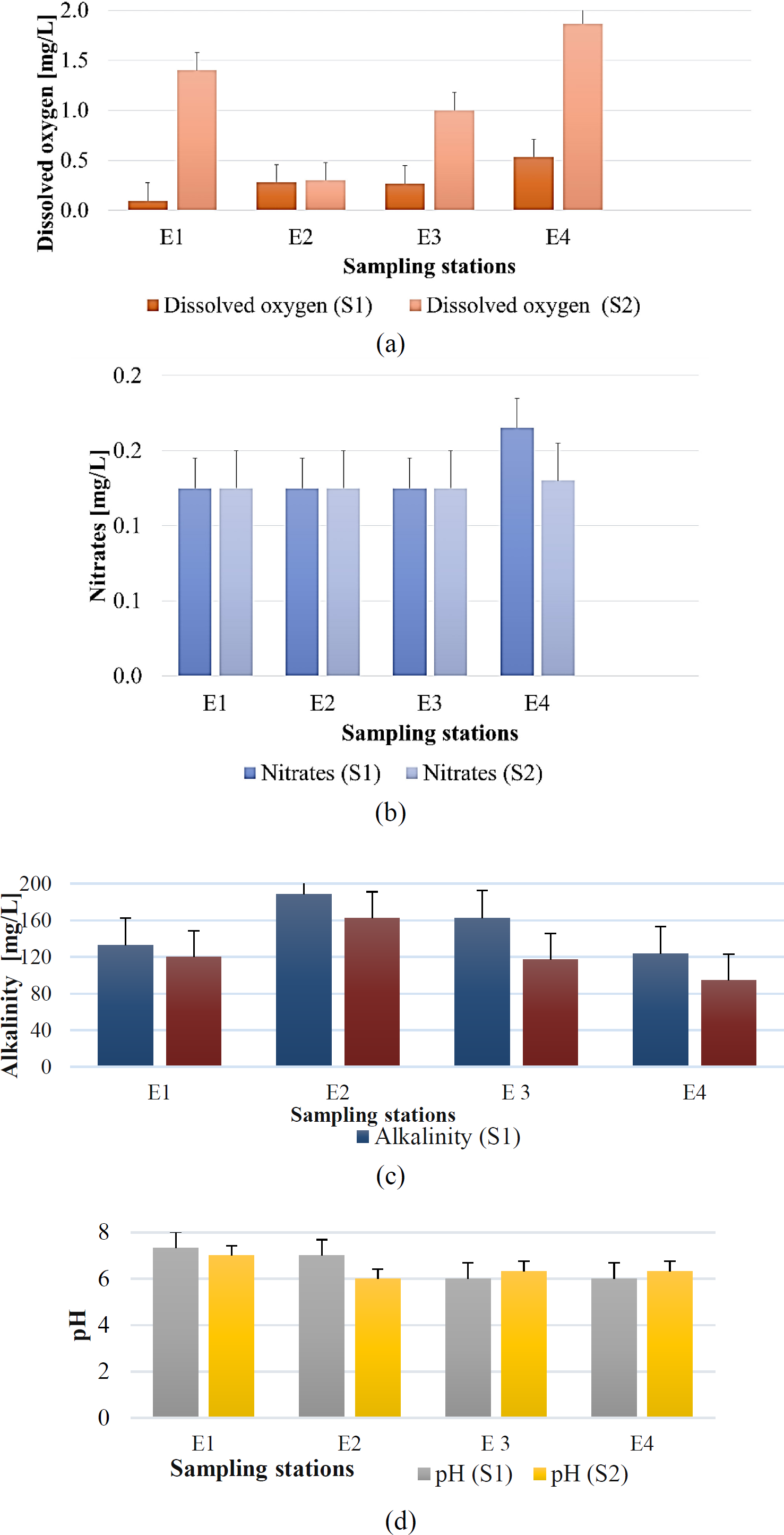
Concerning Figure 1a in the first sampling (S1), there were low or almost zero concentrations of DO; therefore, the general condition of Juan Angola was anoxia. For the second sampling (S2), although the concentrations of DO increased, on average, they did not exceed 2 mg /L in the water. Therefore in that second sampling, the general condition of Juan Angola was hypoxic due to the abuse of waste dumping in the channel during the pandemic and post-pandemic times, to later recover in the dry season of the year. The determination of nitrates, represented in Figure 1b, reveals concentrations at all sampling points below the limit of 50 mg/L established in the standard method. The decrease in DO causes the microbiological reduction of nitrate to nitrite [27]. The low detection of nitrites may be associated with the low concentration of dissolved oxygen in the channel waters during the two samplings, evidenced by the presence of dead fish floating in the water.
Alkalinity and pH are two dependent parameters; the measurements at the sampling stations are shown in Figure 1c and Figure 1d, respectively. Alkalinity values do not exceed 200 mg/L. However, they are higher in S1, relating to the influence of pH, whose results showed a neutral to subalkaline nature. It is recommended by the World Health Organization (WHO) that pH of surface water must be found between 6.5 and 8.5 so as not to affect aquatic life [28]. The alkalinity level is justified by many discharges, mainly in E3, which tend to neutralize the water. Figure 2a and Figure 2b show the air and water temperatures, respectively, at the different sampling stations. According to the WHO, to meet the water and air quality standards, the values must be between 20 and 30 °C [29]. The measured temperatures were found within this range, which implies that the air temperature and the discharges entering the channel do not affect this parameter to a great extent.
Physicochemical parameters measured in the Juan Angola Channel stations: Air temperature (a), Water temperature (b), Transparency (c), and Salinity (d)
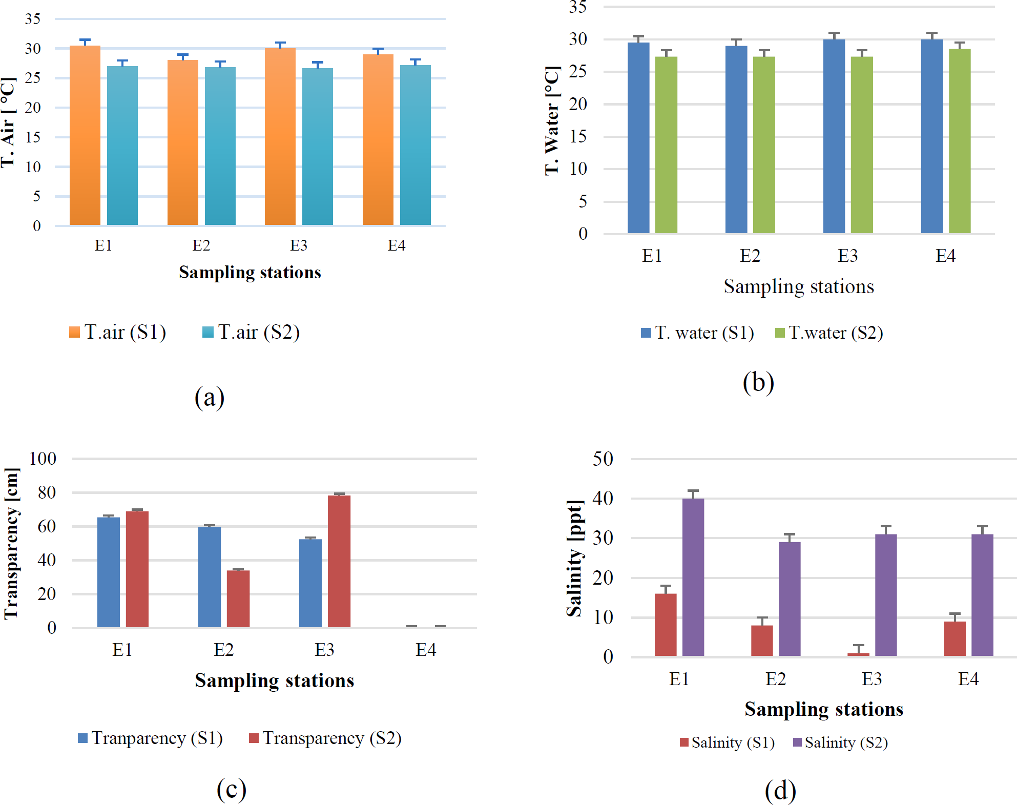
Transparency values are shown in Figure 2c. Transparency indicates the light penetrating a body of water, and turbidity indicates physical contamination from suspended solids; therefore, the higher the transparency, the lower the turbidity. As established by the WHO, the turbidity in a body of water should have a value of 10 NTU [30]. Converting from NTU to Distance ranges in cm, 10 NTU is found in 51.25 to 53.75 cm. For samples S1 and S2, the transparency was above the standard value for all the sampling points. However, in station E4 no, there was a record presenting greater turbidity in the vicinity of the Benjamín Herrera bridge.
The water is considered fresh when the salinity levels do not exceed 500 mg/L or 5×10¹¹ ppt [31]. The salinity at the sampling stations (Figure 2d) was well below this required value for the survival of the species inhabiting the Juan Angola Channel. However, in S2, the values resulting from the natural evaporation process in the Channel were higher for the year’s dry season.
Main component analysis revealed a high similarity ratio between stations E3 and E4. It is therefore worth noting that the variable that identifies them both in the rainy season is diversity, with the two highest Margalef Indexes in the entire dataset, 3.87 and 3.86, respectively, also coinciding with the lowest dissolved oxygen concentrations and salinity of 1 ppt and 9 ppt. It is important to point out that there is currently a narrowing in the channel width in the sector surrounding the E4 station. The high indexes of diversity are due to the attraction to birds, mainly Waders, Continental Waterfowl, Kingfishers, Raptors, Terrestrial Raptors, Carnivores, Scavengers, and Omnivores, as a consequence of the availability of abundant food supply - in this case, dead or anoxia-state fish.
During the rainy season (S1), these two stations were characterized by their transparency (52 cm in E3, while in E4, the Secchi Disc reached the bottom, being still visible) and the concentration of dissolved oxygen (0.27 mg/L and 0.53 mg/L, respectively). Heavy rainfall occurred days before the S1 sampling, so large amounts of sizeable solids were deposited inappropriately in the channel. The obstruction of the channel exacerbates this condition. In these bodies of water, circulation occurs through the change of tides and the effect of communicating vessels between the Bay and the Ciénaga de la Virgen. With the obstruction of the channel, photosynthesizing organisms, and concentration of dissolved oxygen decrease, affecting the health of the fish and even leading to their death. This condition is observed through an unusual increase in water transparency (oligotrophy).
During the dry season (S2), the northeast trade winds blow southwest. The air is very dry, increasing evaporation, considerably decreasing the depth of the channel, raising the temperature, and thus decreasing dissolved oxygen. This condition generates fish death and attraction of opportunistic species, particularly wading birds such as egrets and herons. At this time, salinity increases. Consequently, the cause-effect relationship is clear between diversity - a biological variable, and the physicochemical variables, dissolved oxygen, alkalinity, pH, transparency, temperature and salinity. Anthropogenic effects cause drops in dissolved oxygen, causing the death of fish, which leads to an initial increase in the diversity of birds in search of food, which will decrease over time when many specialist species end up being replaced by a few generalist species.
Although, in Table 1, the total abundance includes all the functional groups, Table 5 summarizes the relationship between the main water parameters and the abundance of generalist (omnivorous), mostly Quiscalus mexicanus and Quiscalus lugubris and specialist (Waders), mostly members of the family Ardeidae (Herons and Egrets).
Relationship between the main water parameters and the abundance of generalist and specialist
| Sampling | Station | Salinity [ppt] | Dissolved oxygen [mg/L] | Transparency [cm] | Omnivores abundance | Waders abundance |
|---|---|---|---|---|---|---|
| S1 | E1 | 16 | 0.10 | 65.50 | 118 | 2 |
| E2 | 8 | 0.28 | 59.83 | 12 | 8 | |
| E3 | 1 | 0.27 | 52.50 | 7 | 10 | |
| E4 | 9 | 0.53 | NR | 12 | 12 | |
| S2 | E1 | 40 | 1.40 | 69.00 | 3 | 7 |
| E2 | 29 | 0.30 | 33.92 | 15 | 19 | |
| E3 | 31 | 1.00 | 78.33 | 12 | 36 | |
| E4 | 31 | 1.87 | NR | 8 | 89 |
The dissolved oxygen in all the stations reflects a condition of hypoxia and nearly anoxia, which is unfavourable for life forms. Juan Angola channel is an affected system. In the rainy season (S1), non-favourable conditions regarding dissolved oxygen were observed. Due to the heavy rainfall, salinity was particularly low. In E1 station, rain drainage channels were open to the Juan Angola system with an important solid disposal that was moved by the rain attracting omnivorous birds such as Q. mexicanus and Q. lugubris.
In the dry season (S2), when the influence of the trade winds and the dryness of the air increases evaporation processes in the system, salinity increases, and the dissolved oxygen is still low. The water system is prone to fish lethargy or death in these conditions. In this season (S2), Egrets were in courtship, demanding a lot of energy and food, and the abundance of dead fish was the feeding ground for this important number of the Ardeidae family members.
Thus, ecosystems that are healthy show higher Shannon and Margalef diversities. In contrast, compromised ecosystems, such as the Juan Angola channel, exhibit low diversity due to the high presence of a certain group of generalist species in the former and specialist species in the latter.
The research results showed notable changes in the number of species and individuals identified in S1 and S2 and the diversity in the different sectors of the channel depending on instantaneous conditions. The effect is unavoidable on the health of all living forms that inhabit the Juan Angola channel, mainly due to several anthropic factors that might affect birds’ abundance and richness. However, this city sector is a flying corridor connecting the bay, the inner channels, and the Ciénaga de la Virgen, making it practically impossible to generalize patterns in the diversity indexes.
On the other hand, the physicochemical parameters showed better results in the second sampling (S2), highlighting dissolved oxygen, alkalinity, and pH; however, salinity and transparency deteriorated for the first sampling (S2) due to a high degree of human intervention on the channel. This fact is exacerbated during the dry season, causing a generalized problem for the city since the channel is a central part of its natural water system. For all of the above, it is possible to affirm that in both samplings, the ecosystem was overexposed caused by discharges of residual waters, garbage, domestic effluents, and affectations by Rafael Núñez airport and the nearby community.
The authors acknowledge the Colegio Montessori Cartagena and Universidad de Cartagena (Colombia) for their support with the development of the research project “TOXICOLOGICAL AND ENVIRONMENTAL EVALUATION OF THE EFFECT OF HEAVY METALS ON THE ECOSYSTEMS ASSOCIATED WITH CAÑO JUAN ANGOLA (CARTAGENA-BOLÍVAR), IN SURFACE WATERS AND SEDIMENTS” (Act 086-2019).
- ,
Water availability footprint addressing water quality ,Journal of Sustainable Development of Energy, Water and Environment Systems , Vol. 7 (1),pp 72–86 , 2019, https://doi.org/https://doi.org/10.13044/j.sdewes.d6.0223 - ,
A literature survey on water quality of Indian water bodies ,Materials Today: Proceedings , Vol. 33 ,pp 412–414 , 2020, https://doi.org/https://doi.org/10.1016/j.matpr.2020.04.552 - ,
Water Quality Simulation and Dissolved Oxygen Change Scenarios in Lam Takhong River in Thailand ,Journal of Sustainable Development of Energy, Water and Environment Systems , Vol. 10 (1),pp 1–13 , 2022, https://doi.org/https://doi.org/10.13044/j.sdewes.d9.0389 - ,
Assessment of Environmental Water Cost Through Physical Hydronomics ,Water Resources Management , Vol. 25 (12),pp 2931–2949 , 2011, https://doi.org/https://doi.org/10.1007/s11269-011-9786-1 - ,
Anthropogenic pollution of aquatic ecosystems: Emerging problems with global implications ,Science of the Total Environment , Vol. 713 ,pp 1–8 , 2020, https://doi.org/https://doi.org/10.1016/j.scitotenv.2020.136586 - ,
Water quality and health risk assessment of the water bodies in the Yamdrok-tso basin, southern Tibetan Plateau ,Journal of Environmental Management , Vol. 300 (June),pp 113740 , 2021, https://doi.org/https://doi.org/10.1016/j.jenvman.2021.113740 - ,
Elucidation of seasonal variations of physicochemical and biological parameters with statistical analysis methods in Puducherry coastal waters ,Marine Pollution Bulletin , Vol. 122 (1–2),pp 432–440 , 2017, https://doi.org/https://doi.org/10.1016/j.marpolbul.2017.05.048 - ,
Assessment of physicochemical properties of water and their seasonal variation in an urban river in Bangladesh ,Water Science and Engineering , Vol. 14 (2),pp 139–148 , 2021, https://doi.org/https://doi.org/10.1016/j.wse.2021.06.006 - ,
Assessment of the surface water quality improvement during pandemic lockdown in ecologically stressed Hooghly River (Ganges) Estuary, West Bengal, India ,Marine Pollution Bulletin , Vol. 171 ,pp 1–11 , 2021, https://doi.org/https://doi.org/10.1016/j.marpolbul.2021.112711 - ,
Environmental and spatial factors affecting surface water quality in a Himalayan watershed, Central Nepal ,Environmental and Sustainability Indicators , Vol. 9 ,pp 1–9 , 2021, https://doi.org/https://doi.org/10.1016/j.indic.2020.100096 - , Perspectiva del Medio Ambiente Urbano: GEO Cartagena, (Perspectives of the Urban Environment: GEO Cartagena), (in Spanish), United Nations Environment Programme (UNEP), District Mayor's Office of Cartagena de Indias and Environmental Public Establishment – EPA Cartagena, 2009
- MIDAS - Digital Interactive Map of Soil Issue, 2019, https://midas.cartagena.gov.co, [Accessed Jun. 30, 2022]
- , Cartagena de Indias. Cinco siglos de evolución urbanística, (Cartagena de Indias. Five centuries of urban evolution), (in Spanish), University of Bogota Jorge Tadeo Lozano, Bogotá, Colombia, 2004
- Globe program and protocols, 2020, https://www.globe.gov, [Accessed: Jun. 20, 2022]
- ,
Looking for indicator bird species in the context of forest fragmentation and isolation in West Kalimantan, Indonesia ,Global Ecology and Conservation , Vol. 27 ,pp 1–23 , 2021, https://doi.org/https://doi.org/10.1016/j.gecco.2021.e01610 - ,
Bird species richness across a Northern Andean city: Effects of size, shape, land cover, and vegetation of urban green spaces ,Urban Forestry and Urban Greening , Vol. 64 ,pp 1–9 , 2021, https://doi.org/https://doi.org/10.1016/j.ufug.2021.127243 - ,
Piecing together cities to support bird diversity: Development and forest edge density affect bird richness in urban environments ,Landscape and Urban Planning , Vol. 213 ,pp 1–14 , 2021, https://doi.org/https://doi.org/10.1016/j.landurbplan.2021.104122 - ,
Waterbird diversity and abundance in response to variations in climate in the Liaohe Estuary, China ,Ecological Indicators , Vol. 132 ,pp 1–10 , 2021, https://doi.org/https://doi.org/10.1016/j.ecolind.2021.108286 - Conservation Ecology: Urban bird diversity and landscape complexity: Species–environment associations along a multiscale habitat gradient, 2003, https://www.ecologyandsociety.org/vol7/iss1/art5/main.html, [Accessed: Jun. 21, 2022]
- The eBird/Clements checklist of birds of the world: v2021, 2021, https://www.birds.cornell.edu/clementschecklist/download, [Accessed: Jun. 30, 2022]
- , Aves acuáticas de Colombia, (Waterfowls of Colombia), (in Spanish), 2021
- , Guía para los grupos de investigación Expedición ONDAS BIO, (Guide for research groups Expedition ONDAS BIO), (in Spanish), 2018
- ,
Aves Em Ecótono Mata Atlântica-Pampa No Sul Do Brasil ,(Birds in the Atlantic Forest-Pampa Ecotone in Southern Brazil) (in Portugese) , Vol. 35 (2),pp 30–40 , 2014, https://doi.org/https://doi.org/10.5902/2179460X12558, Ciência e Natura - ,
Coastal zone habitat-use by birds in Qatar: Insights from a rapid assessment method during spring migration ,Tropical Conservation Science , Vol. 9 (2),pp 658–676 , 2016, https://doi.org/https://doi.org/10.1177/194008291600900207 - ,
Procedimiento de muestreo - Programa GLOBE ,(Sampling Procedure - GLOBE Program) , Vol. 26 (46),pp 68–70 , 2015, UY - , Norma Técnica Colombiana NTC-ISO-5667-3: Calidad del agua. Muestreo. Parte 3: Directrices para la preservación y manejo de las muestras, (Colombian Technical Standard NTC-ISO-5667-3: Water quality. Sampling. Part 3: Guidelines for the preservation and handling of samples), 2004
- ,
Desalination and fate of nutrient transport in domestic wastewater using electrodialysis membrane process ,Desalination and Water Treatment , Vol. 172 ,pp 323–329 , 2019, https://doi.org/https://doi.org/10.5004/dwt.2019.24984 - ,
Study of physicochemical and statistical analysis of water quality parameters in Veeranam Lake, Cuddalore district, Tamil Nadu, India ,Materials Today: Proceedings , Vol. 49 ,pp 2934–2942 , 2021, https://doi.org/https://doi.org/10.1016/j.matpr.2021.11.354 - ,
Comparative study of physico-chemical parameters and water quality index of river ,Materials Today: Proceedings , Vol. 60 ((2)),pp 859–867 , 2021, https://doi.org/https://doi.org/10.1016/j.matpr.2021.09.508 - ,
A comprehensive evaluation of surface water quality and potential health risk assessments of Sisa river, Kumasi ,Groundwater for Sustainable Development , Vol. 15 ,pp 1–13 , 2021, https://doi.org/https://doi.org/10.1016/j.gsd.2021.100654 - ,
Tolerance of freshwater invertebrates to changes in water salinity ,Russian Journal of Ecology , Vol. 34 (4),pp 261–266 , 2003, https://doi.org/https://doi.org/10.1023/A:1024597832095